概要 今回は、Allmapsを使ったジオリファレンスを試します。
https://allmaps.org/
Allmapsは以下のように説明されています。
Allmaps makes it easier and more inspiring to curate, georeference and explore collections of digitized maps.
(機械翻訳) Allmaps を使用すると、デジタル化された地図のコレクションを整理、地理参照、探索することがより簡単かつ刺激的になります。
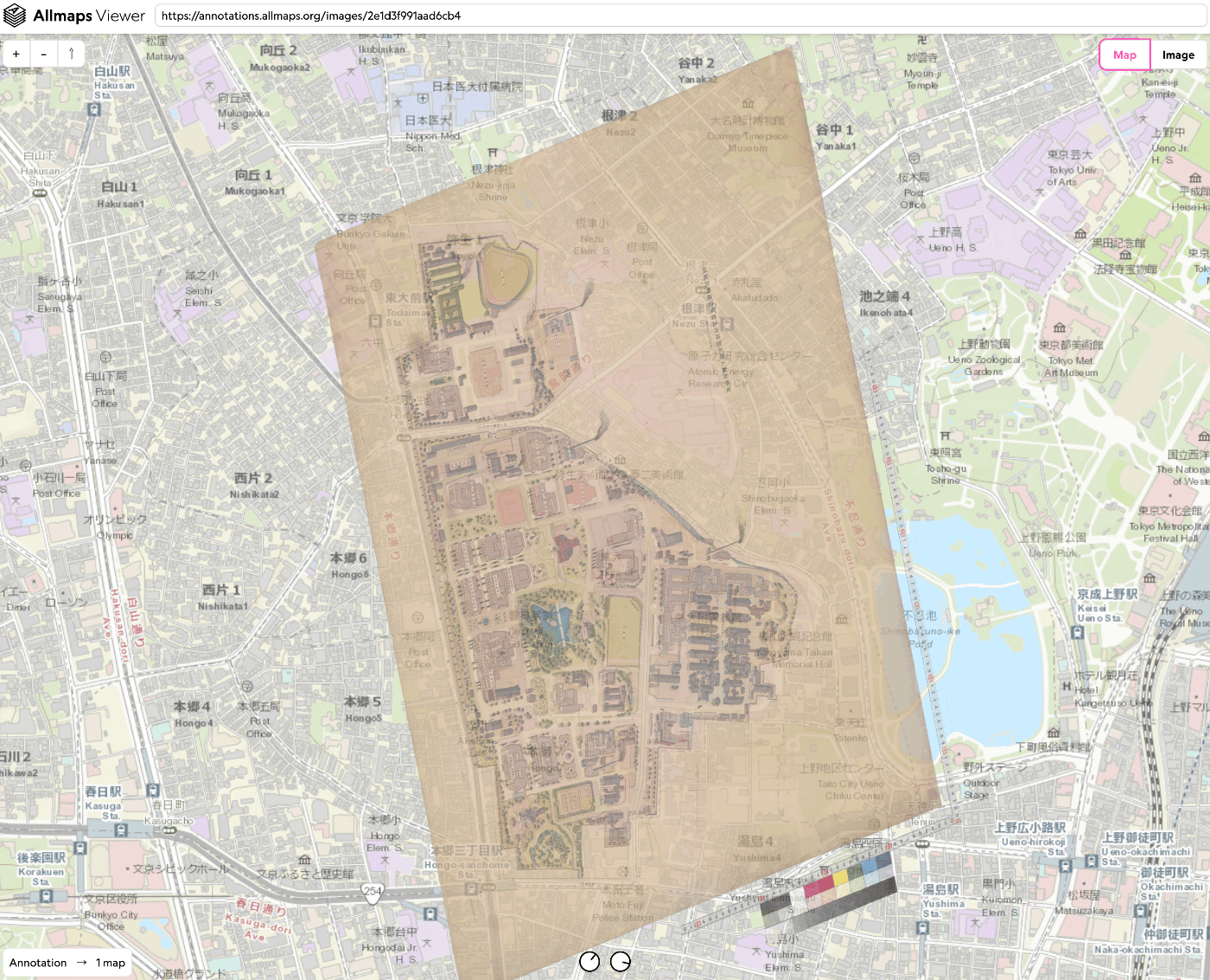
今回は、「東京大学農学生命科学図書館」が所蔵する「東京帝國大學本部構内及農學部建物鳥瞰圖」を使用します。
https://da.dl.itc.u-tokyo.ac.jp/portal/assets/187cc82d-11e6-9912-9dd4-b4cca9b10970
以下のような成果物を作成します。
https://viewer.allmaps.org/?url=https%3A%2F%2Fannotations.allmaps.org%2Fimages%2F2e1d3f991aad6cb4
https://www.youtube.com/watch?v=G0CcXfqo6rs
方法 以下にアクセスします。
https://editor.allmaps.org/#/
今回は、2枚目の画像を使用するので、以下のURLをフォームに入力します。
https://iiif.dl.itc.u-tokyo.ac.jp/iiif/agriculture_re/nou_tatemonochokanzu/0002.tif
以下のようなページで、「Georeference」ボタンを押します。
以下のように、画像と地図が並列に表示されるページに遷移します。画像と地図で対応する箇所をポイントしていきます。
その後、「Results」ボタンを押して、以下の「View current image」リンクをクリックします。
結果、以下のようなビューアのページに遷移します。
作成されるデータ Editor画面で、作成されるJSONデータをコピー、またはダウンロードすることができます。以下のようなJSONデータが作成されました。
{ "type": "AnnotationPage", "@context": [ "http://www.w3.org/ns/anno.jsonld" ], "items": [ { "id": "75912f7214324ea9", "type": "Annotation", "@context": [ "http://www.w3.org/ns/anno.jsonld", "http://geojson.org/geojson-ld/geojson-context.jsonld", "http://iiif.io/api/presentation/3/context.json" ], "motivation": "georeferencing", "target": { "type": "Image", "source": "https://iiif.dl.itc.u-tokyo.ac.jp/iiif/2/agriculture_re%2Fnou_tatemonochokanzu%2F0002.tif/full/full/0/default.jpg", "service": [ { "@id": "https://iiif.dl.itc.u-tokyo.ac.jp/iiif/2/agriculture_re%2Fnou_tatemonochokanzu%2F0002.tif", "type": "ImageService2" } ], "selector": { "type": "SvgSelector", "value": "<svg width=\"18415\" height=\"12911\"><polygon points=\"0,0 0,12911 18415,12911 18415,0\" /></svg>" } }, "body": { "type": "FeatureCollection", "purpose": "gcp-georeferencing", "transformation": { "type": "polynomial", "order": 0 }, "features": [ { "type": "Feature", "properties": { "pixelCoords": [ 6690, 7517 ] }, "geometry": { "type": "Point", "coordinates": [ 139.7623182, 35.7151233 ] } }, { "type": "Feature", "properties": { "pixelCoords": [ 8846, 9181 ] }, "geometry": { "type": "Point", "coordinates": [ 139.7612649, 35.7129321 ] } }, { "type": "Feature", "properties": { "pixelCoords": [ 11626, 8624 ] }, "geometry": { "type": "Point", "coordinates": [ 139.7622949, 35.7109037 ] } }, { "type": "Feature", "properties": { "pixelCoords": [ 12761, 9476 ] }, "geometry": { "type": "Point", "coordinates": [ 139.7618816, 35.7097492 ] } }, { "type": "Feature", "properties": { "pixelCoords": [ 7540, 8365 ] }, "geometry": { "type": "Point", "coordinates": [ 139.7618343, 35.7143244 ] } }, { "type": "Feature", "properties": { "pixelCoords": [ 10681, 5983 ] }, "geometry": { "type": "Point", "coordinates": [ 139.764372, 35.7123118 ] } }, { "type": "Feature", "properties": { "pixelCoords": [ 9304, 5659 ] }, "geometry": { "type": "Point", "coordinates": [ 139.7645652, 35.7135689 ] } }, { "type": "Feature", "properties": { "pixelCoords": [ 3826, 10219 ] }, "geometry": { "type": "Point", "coordinates": [ 139.7594158, 35.7166753 ] } }, { "type": "Feature", "properties": { "pixelCoords": [ 8044, 9859 ] }, "geometry": { "type": "Point", "coordinates": [ 139.76062, 35.7134203 ] } }, { "type": "Feature", "properties": { "pixelCoords": [ 10517, 7862 ] }, "geometry": { "type": "Point", "coordinates": [ 139.7627108, 35.7121183 ] } }, { "type": "Feature", "properties": { "pixelCoords": [ 8892, 9831 ] }, "geometry": { "type": "Point", "coordinates": [ 139.7607901, 35.7126873 ] } }, { "type": "Feature", "properties": { "pixelCoords": [ 14667, 9708 ] }, "geometry": { "type": "Point", "coordinates": [ 139.7620234, 35.7081704 ] } }, { "type": "Feature", "properties": { "pixelCoords": [ 2354, 8506 ] }, "geometry": { "type": "Point", "coordinates": [ 139.7608678, 35.7184833 ] } }, { "type": "Feature", "properties": { "pixelCoords": [ 10054, 8713 ] }, "geometry": { "type": "Point", "coordinates": [ 139.7620034, 35.7122089 ] } }, { "type": "Feature", "properties": { "pixelCoords": [ 5594, 10678 ] }, "geometry": { "type": "Point", "coordinates": [ 139.7593041, 35.7151585 ] } }, { "type": "Feature", "properties": { "pixelCoords": [ 13028, 6647 ] }, "geometry": { "type": "Point", "coordinates": [ 139.7642327, 35.7102509 ] } }, { "type": "Feature", "properties": { "pixelCoords": [ 10685, 10444 ] }, "geometry": { "type": "Point", "coordinates": [ 139.7605725, 35.7111428 ] } }, { "type": "Feature", "properties": { "pixelCoords": [ 4438, 9181 ] }, "geometry": { "type": "Point", "coordinates": [ 139.7606565, 35.7165095 ] } }, { "type": "Feature", "properties": { "pixelCoords": [ 8840, 10491 ] }, "geometry": { "type": "Point", "coordinates": [ 139.7602447, 35.7126024 ] } }, { "type": "Feature", "properties": { "pixelCoords": [ 4667, 10202 ] }, "geometry": { "type": "Point", "coordinates": [ 139.759576, 35.7159457 ] } }, { "type": "Feature", "properties": { "pixelCoords": [ 6762, 10060 ] }, "geometry": { "type": "Point", "coordinates": [ 139.7600401, 35.7144106 ] } }, { "type": "Feature", "properties": { "pixelCoords": [ 8587, 8135 ] }, "geometry": { "type": "Point", "coordinates": [ 139.762299, 35.7134381 ] } }, { "type": "Feature", "properties": { "pixelCoords": [ 7967, 10465 ] }, "geometry": { "type": "Point", "coordinates": [ 139.7600601, 35.7133129 ] } }, { "type": "Feature", "properties": { "pixelCoords": [ 6466, 8313 ] }, "geometry": { "type": "Point", "coordinates": [ 139.7616346, 35.7150937 ] } }, { "type": "Feature", "properties": { "pixelCoords": [ 7569, 7471 ] }, "geometry": { "type": "Point", "coordinates": [ 139.7625263, 35.7143713 ] } }, { "type": "Feature", "properties": { "pixelCoords": [ 10111, 10099 ] }, "geometry": { "type": "Point", "coordinates": [ 139.7607835, 35.7116287 ] } }, { "type": "Feature", "properties": { "pixelCoords": [ 12606, 10162 ] }, "geometry": { "type": "Point", "coordinates": [ 139.7611825, 35.7096128 ] } } ] } } ] } まとめ IIIF対応画像に対するジオリファレンスを行うにあたり、参考になりましたら幸いです。
...